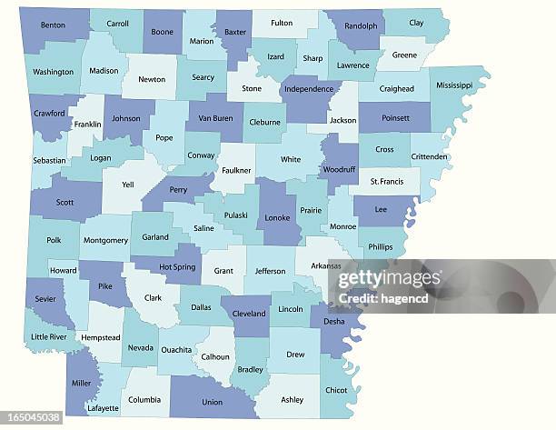
Arkansas state - county map - Stockillustratie
Detailed state-county map of Arkansas. This file is part of a series of state/county maps. Each file is constructed using multiple layers including county borders, county names, and a highly detailed state silhouette. Each file is fully customizable with the ability to change the color of individual counties to suit your needs. Zip contains both .AI_CS2 and .ESP_8.0 as well as a large JPEG file. Map generated using data from the public domain. (http://www.census.gov/geo/www/tiger/) Traced using Adobe Illustrator CS2 on 7/28/2006. 3 data layers.

Bestel uw ingelijste foto direct en bekijk de diverse opties op Photos.com.
LICENTIE KOPEN
Alle royalty free licenties bieden wereldwijde gebruiksrechten en uitgebreide bescherming. Daarnaast zijn er eenvoudige tarieven met volumekortingen beschikbaar.
€ 335,00
EUR
Getty ImagesArkansas State County Map, Stockfoto Download premium, authentieke Arkansas state - county map stockillustraties van Getty Images. Verken vergelijkbare stockillustraties met hoge resolutie in onze uitgebreide visuele catalogus.Product #:165045038
 Download premium, authentieke Arkansas state - county map stockillustraties van Getty Images. Verken vergelijkbare stockillustraties met hoge resolutie in onze uitgebreide visuele catalogus.Product #:165045038
€335€50
Getty Images
In stockGEGEVENS
Credits:
Creatief nr.:
165045038
Soort licentie:
Collectie:
DigitalVision Vectors
Max. bestandsgrootte:
4642 x 3587 px (55,88 x 43,18 cm) - 211 dpi - 5 MB
Datum van uploaden:
Release-informatie:
Geen release vereist
Categorieën: