Map of Egypt and Sudan, showing existing and proposed projects to regulate the flow of the waters of the Nile, including the Aswan Dam and the...
stockillustraties, clipart, cartoons en iconen met berg en hydrografische kaart van afrika - nile river map
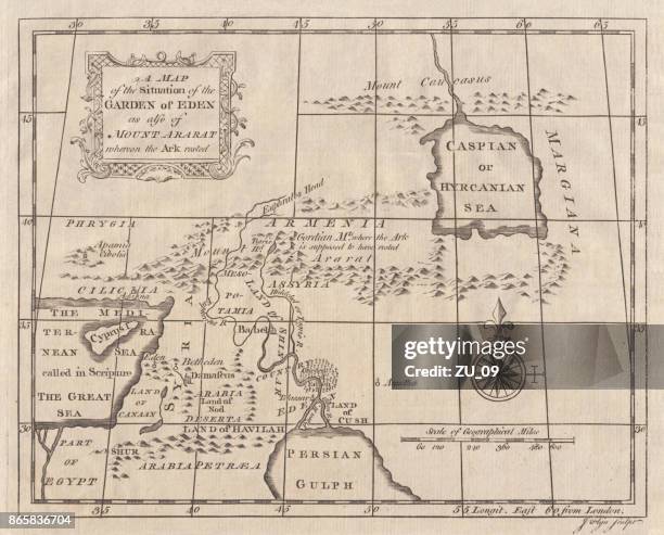
stockillustraties, clipart, cartoons en iconen met kaart van eden en de berg ararat in turkije, copperplate gravure, gepubliceerd 1774 - nile river map
Map of the Delta of the Nile, Showing Sites of Actions and Strategic Points in the Egyptian Campaign, ', circa 1880. Episode of the Anglo-Egyptian...
Picture taken 03 March 2007, shows the site of Amri village north of Sudan capital city of Khartoum , one of several Nile-side communities in...
Sudanese construction worker covers his face against blowing sand at the site of the mega real estate project "Al-Morgan City" at the meeting point...
Sudanese construction staff work at the site of the mega real estate project Al-Morgan city at the meeting point between the White and Blue Nile...
stockillustraties, clipart, cartoons en iconen met historische kaart van de oosterse deel van wereld - nile river map
An 1826 map of Africa shows district boundaries and topographical features. Included are Egypt, Barbary, Soudan, Colony of Good Hope, and other...
Map of the Livingstone and Stanley's expedition to discover the source of the Nile in Central and East Africa. The map is dated 1872, the same year...
Alexandria in Pizzigani's Map, fourteenth century. The river with the buildings on its bank is the Nile.
Battle of the Nile, 1798. Map showing the battle in which the British fleet under Nelson destroyed the French fleet in Aboukir Bay in a battle fought...
'Map of the War in the Soudan', late 19th century, . Map showing Sudan with the River Nile, Khartoum and Omdurman, scene of a battle in 1898 between...
stockillustraties, clipart, cartoons en iconen met map of the exodus or journeyings of the israelites from egypt into canaan - nile river map
stockillustraties, clipart, cartoons en iconen met map of 'modern egypt and sinai' in 1877 - nile river map
old engraved map of the delta of the nile and the suez canal , egypt - nile river map stockfoto's en -beelden
old engraved map of the delta of the nile and the suez canal , egypt - nile river map stockfoto's en -beelden
old engraved map of the delta of the nile and the suez canal , egypt - nile river map stockfoto's en -beelden
Stereoview Slide, a bride's preparations on her wedding day preparing for the ceremony, circa 1900. A maid and friend helping the bride to dress.
Map of Anglo Egyptian Soudan showing The Upper Nile from Korosko to Fashoda, at the time of the Mahdist War. From Field Marshal Lord Kitchener, His...
Upper Nile Basin Map; The regions of the Cazembe', 1875. From, 'Illustrated Travels' by H.W. Bates. [Cassell, Petter, and Galpin, circa 1880,...